
This post by Linda Newland was originally written for the Port Townsend Sail & Power Squadron
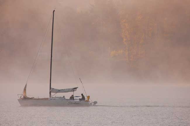
Photo by Doug Kimura
by Linda Newland
The US Coast Guard founded the Puget Sound Vessel Traffic Service in 1972 and although the technology has evolved its purpose remains the same….to facilitate the safe and efficient transit of vessel traffic in the prevention of collisions, groundings, maritime casualties and ensuing environmental damage. Although it is aimed at tracking larger vessels, it can be useful to the recreational boater and should be used in certain cases of restricted visibility.
Twenty-four hours a day, seven days a week, carefully trained military and civilian watch standers monitor and communicate with vessels in the Strait of Juan de Fuca, the San Juan Islands and Puget Sound. VTS even operates with Canada to provide coverage in sea areas near Vancouver, Victoria and up to Tofino out to 60 miles offshore. The VTS center for our area is in Seattle. Periodically larger shipping traffic must call in with their vital information as to speed, heading, destination and estimated time of arrival at various navigation aids. Concurrently, VTS staff are tracking ships by radar on huge flat screen monitors that show their position.
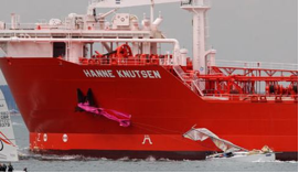
And this happened in bright sunshine.
One of the times you may find it necessary and advisable to call in to report your position and to request information on vessel traffic locations if you find yourself in fog or other restricted visibility and are in the vicinity of or are crossing a Traffic Separation Scheme (traffic lanes, separation zone and connecting precautionary areas) which are shown on navigational charts…both paper and electronic.
You can also become a passive listener to the appropriate VHF channel to listen in on vessel locations. All reporting vessels must monitor both the VTS channel for their area and Channel 13, the Bridge to Bridge channel used for hailing in US waters, on separate radios. They are not required to monitor Channel 16 unless they are able to do so. Smaller vessels in an emergency may not be able to contact a larger vessel on Channel 16 but can contact them using Channel 13. Of course Channel 16 remains the emergency channel for calling the US Coast Guard but that does not help if you have a large tanker bearing down on you in restricted visibility…better to call the ship directly on Channel 13 to make them aware of your location. Bear in mind all that tonnage takes a long time to stop or maneuver so call at your first inclination to do so.
In dense fog, it is advisable to call VTS if you are crossing a highly active traffic lane before navigating across at a right angle. North of Bush Point (on the Whidbey Island side across from the lower end of Marrowstone Island) use VHF Channel 5A. South of Bush Point use VHF Channel 14. Boats should call “Seattle Traffic” several times if you hear no traffic on the channel and identify yourself by the name of your vessel. Sometimes VTS will hear your call but is attending to another vessel that you cannot hear, so they will either not acknowledge your call or will ask you to wait. Be patient, they will come back. If they don’t, call again after a few minutes.
When they answer your call, ask them for whatever information you need and be ready to give them your heading, destination, speed and present location. For instance, if you are trying to cross Admiralty Inlet from Point Wilson to the Whidbey Island side and its foggy, if you have no radar, you may call Seattle Traffic on VHF Channel 5A and ask what, if any, traffic is passing Point Wilson or is in the vicinity. They will not give you advice on whether or not you can safely get across. They will tell you the speed, heading and destination and position of the vessels in the vicinity and leave it up to you to make your own decision. We have waited at Point Wilson doing 360’s in the fog for almost an hour before we could safely get across just because there was so much traffic. Remember also that the Victoria Clipper runs at a much higher speed than the big tankers which still can run at 18 knots.
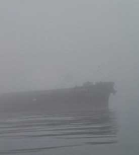
Nothing quite like having a large ship on a crossing course appear unexpectedly out of the fog.
If you are headed for the San Juan Islands, you will need to cross the traffic lanes in Rosario Strait again and will need to call VTS to get the information to make a decision on when to cross for a safe passage. Do not rely on listening to ship engines in the fog as it distorts sound. Instead, call Seatte Traffic to announce your location and get the pertinent information.
Some recreational boaters now have AIS (Automatic Identification System) technology and expect larger traffic to see their boats on the large ship’s screen. This may work better than them picking you up on their radar which is risky even with a good radar reflector. It is more likely you will see them on your AIS screen. VTS only tracks Class A, AIS, not Class B which most recreational boaters are buying. Basically, unless you call in to VTS, they are not seeing you on their radar or tracking you on their screen. In restricted visibility, your chances of a larger ship seeing your AIS signal or seeing you on radar in time to avoid a collision is very minimal.
The USCG advises smaller boats to monitor the proper VTS channel and be ready to call a ship, if you’re unable to determine its intentions, on VHF channel 13. In restricted visibility, get the appropriate information from VTS so you can make a safe decision on crossing traffic lanes. Be a silent listener at other times on VTS so you are informed of large ship movement.